


Open data available
Today we supply real-time data to apps with over 7 million unique customer downloads in total. The Open Data program will make these datasets, along with other transport data, more broadly available. This data will be capable of supporting apps and a whole lot more.
Learn More

Get started!
We have a range of resources to help you get started using our data. Read through our user guide, API basics or documentation for information or visit the troubleshooting page if you are stuck.
Learn more

Transport for NSW Innovation
Transport for NSW is committed to fostering innovation by providing open access to our data. Future Transport holds a number of events and challenges to uncover new ways of using our data.
Learn more
Product Showcase

AnyTrip
Overview
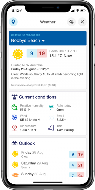
AnyTrip lets you track public transport vehicles around you in real-time using a live map. It will also show you upcoming departures from your favourite stops and stations. Check which service you are currently travelling on Check real-time departure information Get an at-a-glance view of all public transport across NSW Access AnyTrip web app through a web browser.
Datasets
- Trip Planner API
- Public Transport - Timetables - For Realtime
- Public Transport - Location Facilities and Operators
- Traffic

Boatable
Overview
Log your trip with Boatable and enjoy the waterways safely with tips before you head off, and alerts while out and about. Boatable is a boating assistance app that helps recreational boaters navigate the seas. It includes features such as a range of maps, boat detail records, weather, logging of trips and safety information for both on and off the water.
Boatable is endorsed by Transport for NSW following the Boating Companion Innovation Challenge in 2018.
Datasets
AidToNavigation: channel markers and other selected aids to navigation
BoatRamp: boat ramps with attributes as displayed on the boat-ramp locator on the RMS website
CoastalBar: indicative locations of coastal bars as described in the Marine Safety Regulation 2016
NoTowing: areas where towing of persons is prohibited as designated by signs along the waterway
NoWash: areas where the generation of wash is prohibited as designated by signs along the waterway
PublicMooring: courtesy and emergency moorings
RestrictedZone: areas of restricted waters for port security or naval purposes
Speed: areas of speed limits (in knots) as designated by signs along the waterway
ShallowWater: areas of assumed shallow water (depth of less than approximately 2 metres in tidal waters and the shallower water in inland waters at full supply)
Speed: areas of speed restrictions (in knots) as designated by signs along the waterway
WebCamera: locations of bar cameras, including URLs to webpages on the RMS Internet site for viewing of the live feed

Bustle
Overview
Bustle is an Australian first implementation of digital advertising screens together with real-time Public Transport information. Combining advertising and public transport information creates a unique service to naturally capture attention of customers and provide a community service.
Screens are customised with local Train / Metro / Light-Rail and Bus real-time information. In a world where brands are fighting to be noticed and people's attention is short - Bustle creates a unique experience for your customers to remember you.
Datasets
Timetables Complete GTFS
Public Transport - Timetables - For Realtime

Citymapper
Overview
Citymapper is a multi-modal trip planning app, making cities easier to use. The app allows for checking of nearby departures in real-time and has the ability to find the fastest route combining bus, train, ferry, light rail, taxi, car share, bike share and walking. Commuters can decide which transport option based on time, the amount of calories burned, and also receive alerts for route disruptions and more.
Citymapper is endorsed by Transport for NSW following the Travel Choices Innovation Challenge in 2017.
Datasets
Public transport scheduled and real-time information
Deckee
Overview
Deckee is a social app that helps boaters explore the waterways safely, share fishing and anchorage reports, find local marine services and much more.
Deckee is a boating assistance app that helps recreational boaters explore the waterways through a community-based contributions. It also has safety alerts, weather conditions, helps with boat insurance finding all in one app.
Deckee is endorsed by Transport for NSW following the Boating Companion Innovation Challenge in 2018.
Datasets
AidToNavigation: channel markers and other selected aids to navigation
BoatRamp: boat ramps with attributes as displayed on the boat-ramp locator on the RMS website
CoastalBar: indicative locations of coastal bars as described in the Marine Safety Regulation 2016
NoTowing: areas where towing of persons is prohibited as designated by signs along the waterway
NoWash: areas where the generation of wash is prohibited as designated by signs along the waterway
PublicMooring: courtesy and emergency moorings
RestrictedZone: areas of restricted waters for port security or naval purposes
Speed: areas of speed limits (in knots) as designated by signs along the waterway
ShallowWater: areas of assumed shallow water (depth of less than approximately 2 metres in tidal waters and the shallower water in inland waters at full supply)
Speed: areas of speed restrictions (in knots) as designated by signs along the waterway
WebCamera: locations of bar cameras, including URLs to webpages on the RMS Internet site for viewing of the live feed

EasyDrop
Overview
EasyDrop is an interactive app for commercial delivery drivers. The app helps drivers manage their daily delivery schedule, find the fastest route and provides up to date traffic conditions. Drivers can also stay in touch with their customers through the app; with one click delivering becomes delivered! Developed by OzPoint. View the developer discussing their relationship with TfNSW here
Datasets
Roads real-time information

Embark
Overview
Embark not only lets you plan trips around greater Sydney, but works in hundreds of cities around Australia and the world - now there's no need to download a new transport app when you're travelling.
Embark shows you live arrival times for buses, trains, light rail, ferries, Uber, and more. Additionally, Embark also gives you insight into calorie burn for walking routes, carbon emissions comparisons for public transport routes, and wheelchair accessibility information for each service.
Accessible Travel
- Provides wheelchair accessibility information for supported services
- Supports VoiceOver for iPhone

finderful.com
Overview
finderful.com is a website designed to help you decide where to buy or rent in Sydney, New South Wales, and Australia.
You can search for homes or suburbs based on a wide range of customisable search preferences you set, including number of bedrooms and bathrooms, safer suburbs, or cheaper homes. finderful.com uses Transport for NSW public transport datasets in its searches to calculate travel times from every home to your workplace or any other point of interest. It even lets you select your preferred transport mode!
finderful.com is endorsed by Transport for NSW following the Travel Choices Innovation Challenge in 2017.
finderful.com can help you find homes and suburbs that best suit you.

Google Maps
Overview
Navigate your world faster and easier with Google Maps. Over 220 countries and territories mapped and hundreds of millions of businesses and places on the map. Get real-time GPS navigation, traffic, and transit info, and explore local neighbourhoods by knowing where to eat, drink and go - no matter what part of the world you’re in.
Accessible Travel
Provides accessibility information for travelling with a wheelchair.
Datasets
- Timetables Complete GTFS
- Public Transport - Timetables - For Realtime
- Public Transport - Realtime Alerts
- Public Transport - Realtime Vehicle Positions
- Public Transport - Realtime Trip Update
- Public Transport - Location Facilities and Operators

L2P
Overview
L2P app is a digital logbook designed for the latest generation of learner drivers. Its intuitive user interface features a countdown to motivate learners, real time tracking and recording of driving sessions plus an online educational platform with video clips for demonstrations.

Licence Ready
Overview
With digital driving instruction, personalised training and NSW log book, this is a fantastic app for learner drivers. Download across devices and utilise with multiple supervisors for flexible learning.

Live Traffic NSW
Overview
Live Traffic NSW provides to-the-minute updates about incidents and conditions that may affect a user’s journey. Users can save their favourite routes to receive scheduled alerts and can check images from live traffic cameras that update every 60 seconds. The app also enables Driving Mode so users can receive audio alerts of nearby incidents while on their trip. Live Traffic NSW can be used in both Sydney and regional NSW.
Datasets
Live traffic information

Metarove
Overview
Metarove was developed to make public transport trip planning easier for customers with limited mobility. The app provides real-time information about departure times, route recalculation, trip plan updates and options if services are delayed or cancelled. The app is highly customisable and users can set personal walking speeds, maximum physical travel distances or display accessible journeys only. Developed by Metarove. View the developer discussing their relationship with TfNSW here or see how Metarove works for customers with limited mobility here
Datasets
Public transport scheduled and real-time information

Moovit
Overview
Moovit provides users with real-time information and fastest routes for the public transport network. Users can send live reports about their travel experience, such as cleanliness and seat availability, through the app. This live information helps improve route plans and provides other users with more accurate travel time estimates. Developed by Moovit.
Datasets
Public transport scheduled and real-time information

My House Geek
Overview
My House Geek allows users to get to know a neighbourhood before they move in. A map allows users to search for properties, as well as discover nearby schools, public transport services and other places of interest such as shopping centres and child care facilities. Using transport data, the map shows users how far places of interest are from their selected property. Users can even save and share all searches!
Next Station
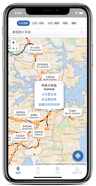
Overview
Next Station provides trip planning and timetables, real-time vehicle position and service alerts in English, Simplified and Traditional Chinese covering Sydney’s public transport network, NSW TrainLink and NSW regional buses.
【Next Station 下一站】提供6大服务,包括 1. 行程规划,2. 实时时间表,3. 实时公交位置,4. 实时中文服务信息,5. 路线地图,6.车厢空间拥挤度。【Next Station 下一站】涵盖火车,城轨,公交,轻轨及渡船。【Next Station 下一站】提供全中文界面及实时翻译所有公共交通服务信息。
【Next Station 下一站】提供6大服務,包括 1. 行程規劃,2. 實時時間表,3. 實時公交位置,4. 實時中文服務信息,5. 路線地圖,6.車廂空間擁擠度。【Next Station 下一站】涵蓋火車,城軌,巴士,輕軌及渡船。【Next Station 下一站】提供全中文界面及實時翻譯所有公共交通服務信息。
Datasets
- Public transport schedules and real-time information

NextThere
Overview
NextThere provides users with real-time service information. The app tracks a user’s location and shows when the next trains, buses, ferries or light rail are due to depart from that location. An easy-to- read map tracks services and users can receive alerts about disruptions before their journey. Developed by AppJourney Pty Ltd.
View the developer discussing their relationship with TfNSW here
Datasets
Public transport scheduled and real-time information

Opal Travel
Overview
Opal Travel allows users to plan their trip and check their Opal fare estimate for train, bus, ferry and light rail services.
Adult, child/youth and senior/pensioner fares are displayed as well as Opal card retailers. NFC Android users can also scan their Opal card to check their balance, journey count and last tap details.
Details of a trip plan can be displayed as a map or as text-based instructions, and user can receive service alerts. Users can also save regular trips and locations as favourites. Trip planning is enabled for both Sydney and regional NSW.
Datasets
Public transport scheduled and real-time information

Rome2rio
Overview
Rome2rio is a global travel planning website and app that allows users to quickly find their way from A to B using any combination of transport.
Simply type in two addresses anywhere in the world and you’ll be offered a choice of journey options that seamlessly stitch together flights, transfers, trains, ferries, and buses, to get you from door to door – all with prices, estimated durations, and booking details at lightning-fast speed.
Rome2rio covers 10 million locations around the world and includes routing from more than 5,000 transportation operators.
Datasets
Timetables Complete GTFS

Roundtrip
Overview
Roundtrip is an app for NSW Learner Drivers that makes it super easy to record supervised driving practice. Tap the record button, enter your odometer and you’re off! Roundtrip will track your time, start and end location, weather and more, so you focus on learning to drive. You can also use Roundtrip to view and unlock learning goals, see your total practice times and submit your digital logbook to the RMS. No more paper logbook needed!

Snarl
Overview
Snarl provides up-to-date information about accidents and congestion across the NSW, QLD and VIC road networks. Users can check traffic conditions before their journey, or on the go using driving mode. In driving mode, auto driving detection will warn users of current conditions, accidents and incidents while they are on the move. Developed by Snarl.
View the developer discussing access to open data here
Datasets
Roads real-time information

Stop Announcer
Overview
Stop Announcer is a route guidance app that provides audio notifications of stops made along a trip. The app will announce bus stops, train stations, ferry wharves and light rail stops. It will also alert users when their selected stop has been reached.
View the developer discussing access to Open Data here
Datasets
Public transport scheduled and real-time information
Transit
Overview
Transit App provides real-time trip planning including departure times, timetables and route maps all in big text and bright colours. Users can set reminders, get notifications about disruptions and view visual stop notifications on a map. The app also allows users to request an Uber. Developed by TransitApp, Inc.
Datasets
Public transport scheduled and real-time information

TripChecker
Overview
TripChecker is the world's free, take-anywhere transit companion. Users can get live vehicle departures and key travel info in Sydney, London and New York - and other major cities around the world, including every town in Great Britain. Next train or bus arrival is instantly shown to users, as well as live journey planning, instant disruptions info and traffic reports. TripChecker will even wake users when they arrive at their stop!
Datasets
Public transport scheduled and real-time information

TripGo
Overview
TripGo allows users to compare public and private transport options.
It provides information including estimated costs , fastest modes and routes based on real-time data. Users can manually search for trip options, or TripGo can use their calendar to provide options automatically. The app can also provide users with door-to-door directions.
Developed by SkedGo. View the developer discuss their relationship with TfNSW here
Datasets
Public transport scheduled and roads real-time information

Triptastic
Overview
Triptastic shows users the next available service from their current location, service disruption information and vehicle tracking. From within the app users can search for suburbs, routes, stops and businesses or explore a range of interactive, detailed maps of routes, stops and service frequencies.
Developed by AppJourney Pty Ltd.
Datasets
Public transport scheduled and real-time information

TripView
Overview
TripView displays train, bus, ferry and light rail timetables for Sydney. Users can view a summary of next services or a full timetable. Alarms can also be set for upcoming trips.
Developed by Grofsoft.
Datasets
Public transport scheduled and real-time information

Waverley Transport
Overview
Our hyperlocal MaaS solution provides multimodal journey options for customers to have a seamless travel experience. It is customised for the Waverley Council area. The main objectives are easing traffic congestion and reducing parking demand.
Developed by Smart Cities Transport (SCT)
Datasets
Public Transport - Real-time Trip Update
Public Transport - Timetables - For Realtime
Other datasets including Waverley Council Datasets
Performance and Analytics
Transport Performance and Analytics (TPA) operates as a Centre of Excellence, providing objective and credible transport data, advice and analysis. TPA combines the Bureau of Transport Statistics and Bureau of Freight Statistics and provides the evidence base that helps drive strategic decision making in support of an effective transport system.
MoreSince the launch of the Open Data Hub...
44,014
Registered Users
5,859
Registered Applications
8,661,416,840
API Hits